Home
Company
About Us
Accreditations
Land
Boundary Surveys
Topographic Surveys
Measured Building Surveys
3D Scan to BIM
Civil Engineering Services
Marine
Hydrography
Dimensional Control
Marine Engineering
Vessel Information Modelling
Dockyard Asset Surveys
Vessel Charter
Projects
Case Studies
Technology
World Project Map
Customer Feedback
News
GEO
BASE
Contact
We apply best practices to all our projects, whether that’s a residential garden Topographic Survey, a nearshore Hydrographic Survey or a high profile complex Dimensional Control Survey.
Projects
Projects
Case Studies
We apply best practices to all our projects. Here are some of the ones we can chat about!
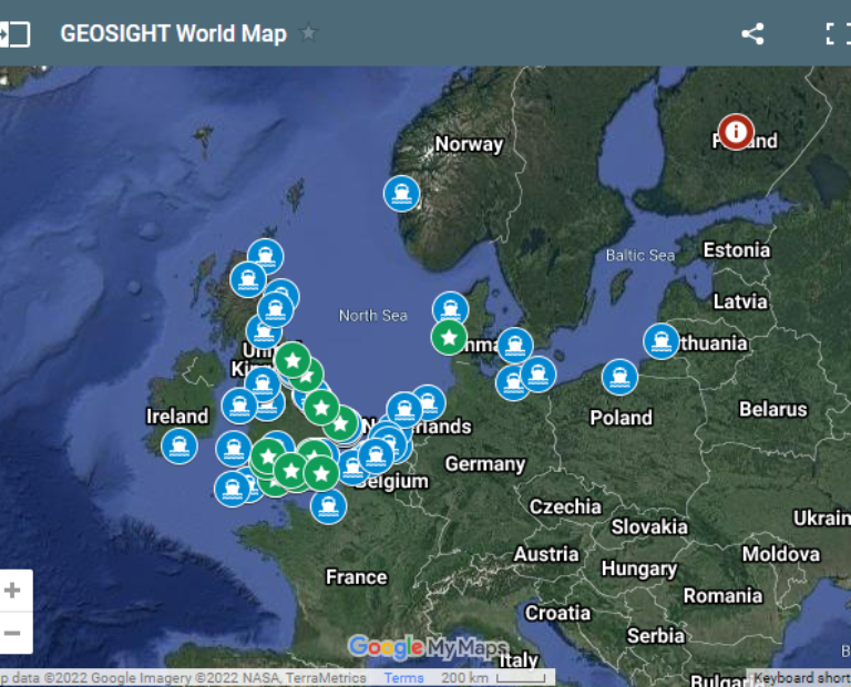
World Project Map
Insight to the world locations we have had the pleasure of conducting dimensional control and hydrographic survey work.
Technology
Take a look at some of the equipment we use on a day to day basis.
Feedback
A selection of the wonderful feedback we have received from our fantastic clients.
Take a look at our Instragram below:
geosight
Emerging form hibernation. The next time we see Ta
Summer will soon be here and land survey will be l
Full ocean depth MBES only work with a highly accu
Back to the sea.
8 Vessel dimensional control surveys complete this
It’s dark!
The inaugural GEOSIGHT vessel dimensional control
Just a bit snowy here!
True commitment from the guys braving the Scottish
Cracking day at the track. Team GEOSIGHT enjoying
Livingstone I presume!
A quick walk around the office highlights the dive
Brian and Rob receiving the new 1”TS15 and sligh
Ok team - we’re going to Mars.
Now there is a man outstanding in his field. #surv
Vessel modelling for virtual deck layout planning
Cooee….
Boat on boat.
Thanks to @leica_geosystems for delivering our new
USV upgrade #surveylife #civilengineer #hydrograph
Load More…
Follow on Instagram